Natural Science - Year II
Unit 41: Early Plate Tectonics

History Weblecture for Unit 41
| This Unit's | Homework Page | History Lecture | Science Lecture | Lab | Parents' Notes |
History Lecture for Unit 41: Wegener and Plate Tectonics
For Class
- Period: 19th - 20th Century
For the interactive timelines, click on an image to bring it into focus and read notes.
Click on the icon to bring up the timeline in a separate browser window. You can then resize the window to make it easier to read the information.
Click here: Timeline PDF to bring up the timeline as a PDF document. You can then click on the individual events to see more information if you want. Exploring this version of the timeline is optional!
- Geographic Location: Europe, USA
- People to know: Alfred Wegener, Alexander du Toit, Arthur Holmes, Harry Hess, Frederick John Vine, Lawrence Morely, John Tuzo Wilson
- See science topics: Plate Techtonics
Outline/Summary
Wegener and Plate Tectonics
As far back as 1596, mapmakers recognized that the Americas' east coast outline would "fit" up against the European and African western continental coastlines. Abraham Ortelius suggested that the continents had once been joined; the idea caught the imagination of Francis Bacon, Benjamin Franklin, and Alexander von Humboldt, but none of them were able to suggest a mechanism that would account for the movement of such huge land masses in a supposedly solid earth.
In the late nineteenth century, the Italian scientist Roberto Mantovani proposed that the earth originally had a single crust continent (now identified with Pangaea), which broke apart as the earth expanded from internal thermal pressure. This theory has been discounted, but it provided food for thought for later geologists.
In response to the controversies over formation mechanisms raised by Lyell and Agassiz, Alfred Wegener in 1912 came up with a model now called plate tectonics (he called it "continental drift"). Wegener suggested that the continents floated on the deeper layers of rock in the earth, and moved together and apart, driven by slow currents. At some time in the past (about 200-300 million years ago), all the continents formed a single land mass called Pangaea, and animals and plants migrated freely from one area to another, a process that would explain why we find similar species on bodies of land now widely separated by the oceans.. According to Wegener's theory, once the continents separated, any new species which developed would do so in isolation from the other continents. His theory also accounted for the similarity in coast lines between South America and Africa. Because Wegener could not produce measurements confirming actual plate movement in his initial book, The Origin of Continents and Oceans (1915), his theory was not well received.
Read about Alfred Wegner at the Berkeley paleontology site.
- Where was Wegener educated? What subjects did he study? Why did he turn to geology?
- What is a "land bridge"? How were they used to explain the distribution of animals on different continents?
- Who were Wegener's supporters?
Support for Wegener's theory
The South African scientist Alexander du Toit mapped large portions of the basalt and dolorite structures in the Karoos area from 1900-1920. In the 1920s, he received grant money to travel to South Africa, where he was able to show from stratigraphic (structural) and radioisotope (chemical composition) evidence for strong similarities between structures on the African and South American coasts.
In 1928, a British geologist, Arthur Holmes, suggested that the earth's interior could be separated into layers with rising and falling thermal heat cells, and that this convection model could be used to explain the motion of Wegener's continents if they were viewed as solid masses floating in the top layer of molten mantle, driven together or apart by thermal currents. Holmes knew that his theory lacked hard observational evidence. In his later work, he used the relative abundances of radioactive forms of uranium to estimate the earth's age at 4.5 billion years — a figure still accepted by most geologists.
During the war in the Pacific between 1940 and 1945, US Naval Officer Harry Hess used the time between battles to map the ocean floor. In 1962, he published a paper called "the History of Ocean Basins' that explained a mechanism for seafloor spreading. His theory explained how the ocean floor is recycled so that strata do not build up as they do on the continents. The theory was consistent, but he had no hard evidence for the actual movement of the ocean floor, based on the relatively short time (geologically speaking) that he was able to take measurements.
The definitive evidence Hess lacked was supplied by geophysicists Frederick John Vine and Lawrence Morley, who independently submitted papers providing evidence from magnetic patterns in ocean floor strata. Although Morley's paper was submitted first, it was rejected by the publishers of Nature, so Vine published first. Their explanation of magnetic reversal is now called the Morely-Vine-Matthews hypotheis, which also gives credit to Vine's advisor, Drummond Matthews. According to this theory, iron fragments in the molten extrusions would be free to align with the earth's magnetic field. Since this field reverses periodically, rocks on the ocean floor should show different patterns, reflecting the earth's magnetic field at the time the rock was extruded.
Read the description of the magnetic field symmetry analysis as the USGS site.
One of the earliest geologists won over by the new evidence was a Canadian, John Tuzo Wilson. Building on Wegener's original ideas and the new evidence, Wilson formulated our modern theory of plate tectonics. As a result of his integration of physical processes with newly-available observational evidence, including satellite measurements that confirmed that the continents were changing positions, most geologists now accept plate tectonics as the explanation for the earth's continents, as well as a number of phenomena, such as the concentration of earthquakes and volcanic activity along plate boundaries.
Planetology
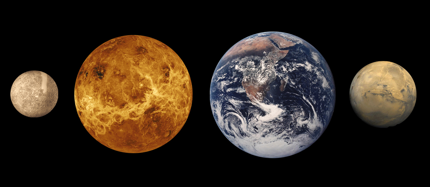
The information sent back by planetary exploration probes like Voyager in the 1980s, and Galileo in the 1990s have allowed earth geologists to extend their investigations to other bodies in our solar system. We now know that most planets have a single tectonic plate, however deformed (Mercury), pocked by volcanoes (Venus) or cracked (Mars). Earth appears to be unique in the solar system in its possession of more than one tectonic plate. This may be a result of the work of lunar gravitational pull on the Earth's crust, because no other planet has a moon so comparatively large compared to its planet.
The study of the earth from space has allowed us to determine something about its core structure by examining its mass and magnetic field.
Read about the earth's structure at the ThinkQuest Spaceship Earth site. You can explore more of this site from the Home link at the bottom of the page but for this unit, you only need to look at the Earth Structure pages. Study the overview page, and the pages on the Core, Mantle, and Crust.
- What are the four layers of Earth considered as a whole planet?
- What is the difference between the inner and outer core?
- Where does Earth's magnetic field come from?
- How thick is the mantle?
- What is the crust?
Study/Discussion Questions:
- Why was Wegener's theory not accepted during his lifetime?
Further Study/On Your Own
- Visit the Paleontology Without Walls site; this is the University of California Museum of Paleontology at Berkeley. It has good online exhibits presenting information about the current theories of the age of the earth and the evolution of life.
- Here's a another brief account of the development of plate tectonics theory, including du Toit's original map.
© 2005 - 2026 This course is offered through Scholars Online, a non-profit organization supporting classical Christian education through online courses. Permission to copy course content (lessons and labs) for personal study is granted to students currently or formerly enrolled in the course through Scholars Online. Reproduction for any other purpose, without the express written consent of the author, is prohibited.