
Natural Science - Year I
Unit 5: Planetary Motions

Lab Assignment for Unit 5
| This Unit's | Homework Page | History Lecture | Science Lecture | Lab | Parents' Notes |
Natural Science Unit 5 Laboratory Activity:
Planetary Movements
Goal: Observing planets against the background sky
Materials and Equipment:
- Naked eye, telescope, or binoculars
- Star maps such as this one from the Sky Safari planetarium program. Any map tha shows the constellations and planetary positions will work.
Procedure:
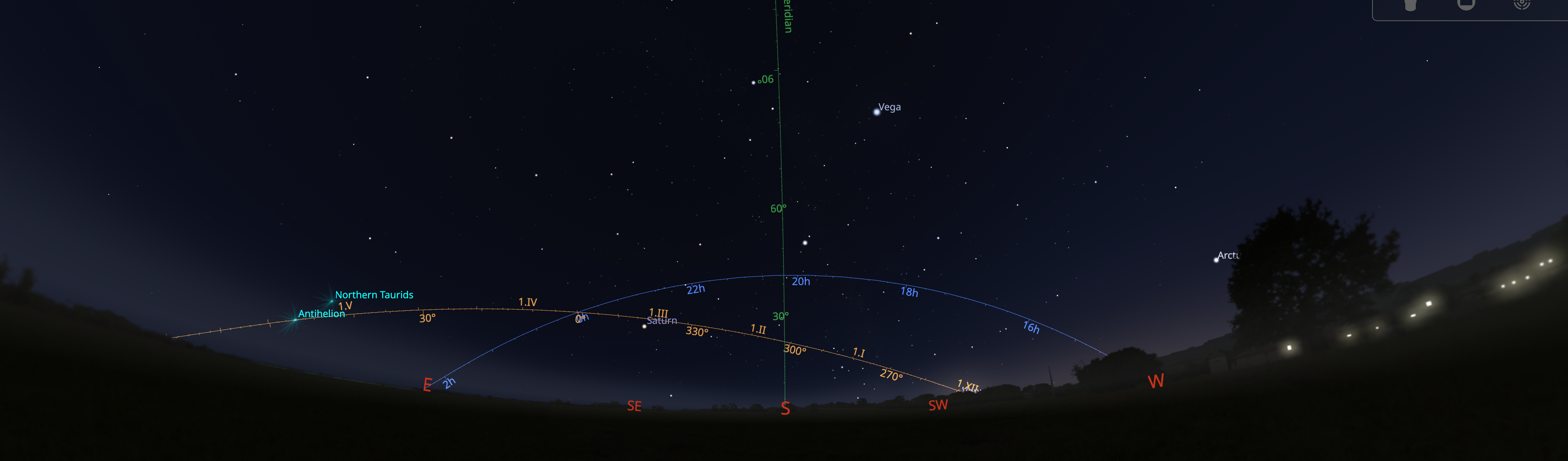
Attached is a map of the Seattle, WA sky, for 23 October 2024 at 07:00 pm, local Daylight Savings Time. The middle slightly-curved green line is your horizon; notice the compass points along it. You are looking south in this partial view. The area below this line shows the stars that are below the horizon. The curved orange line is the path of the sun (called the ecliptic) against the background of the sky. The blue line is the celestial equator. Points along this line are marked at the boundaries of the diagram in hours of right ascension. The sun is near 12 hours of right ascension at the autumnal equinox, half-way around the sky from its 0 hour position at the vernal equinox.
Using the map as a starting point, choose a clear night at a reasonably light-free location, begin observing as soon as it is dark enough, and try to locate the following objects:
- the moon, if it is visible (it will be at first quarter on October 16; notice it's position on the map above the south horizon)
- the constellations Pisces and Sagittarius (these lie along the ecliptic)
- the constellation which is setting in the west
- the constellation which rising in the southeast
- the planets Mars and Mercury will set before the sun sets; if you want to see them, you will need to get up before dawn.
- the planet Venus will set after sunset; you might see it earlier in the evening -- at 9pm it is already set.
- the planets Saturn and Jupiter, pretty much due south.
- if you know other constellations, you may want to try and find them as well.
- note any differences in locations between your observations and the ones on the map (is Aquila directly over head? what time is it?)
Data Analysis:
There is no formal data analysis for this observation.
Report:
Your written report should include the following sections:
- Your observing location (city and state, latitude and longitude)
- Your observing conditions (clear, somewhat hazy, dark sky, light sky)
- The dates and times of your observations
- The appearance and position of the moon
- The constellations that you were able to identify
- The appearance and location of the planets you were able to find
© 2005 - 2026 This course is offered through Scholars Online, a non-profit organization supporting classical Christian education through online courses. Permission to copy course content (lessons and labs) for personal study is granted to students currently or formerly enrolled in the course through Scholars Online. Reproduction for any other purpose, without the express written consent of the author, is prohibited.